A few weeks ago I posted an earlier article titled ‘The Wheels of Progress’ and included in this post was a section of a map showing the Borough of Walsall from 1814. This map section has now found its way onto the Facebook pages of Walsall Past and Present with no explanation as to its meaning, it is described to readers as being an 1814 map of Walsall and not part of a map of Walsall. To clarify matters I decided to attempt an explanation.Read More »
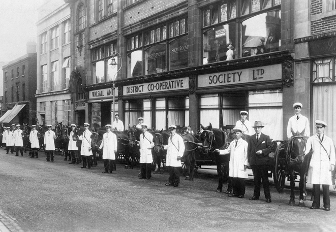
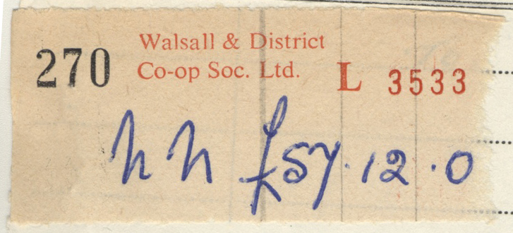
This popular photograph shows the milkmen of the Co-op posing with their trusty steeds outside the main offices and store in Upper Bridge Street in the 1930s.The familiar stub from the Walsall & District Co-op. Not one of my Mom’s sadly, you could get some divi’ off 57 quid!
Apologies to any reader who thinks this post is going to be a history of the Co-operative Society in Walsall, sorry to disappoint, but is not, merely observations accompanied by some of my photographs. As a lad growing up in the 1950s one number I never forgot, apart from our house number, was Mom’s Co-op divi’ number….12530. It’s still embedded in my brain today, no prompting required!
My local branch was a grocery store on the corner of Sandwell Street and West Bromwich Street and I was in and out of there like a ferret down a hole doing errands for the older women who lived by us. Mrs Tombs was one, she lived to be about a 102 if I remember correctly, a grand old lady who always had a good tale to tell, another was Mrs Lockley from 228, Mrs Clayton of 224, my gran at 226, Dora Johnson who lived with her brother and dad at 222, Mrs Lewis, a widow at 218 and two sisters who lived at 216, Miss Stokes and Mrs Wynne. The latter pair were daughters of Alfred Stokes who was captain of Walsall Swifts football club and forerunners, along with Walsall Town, of Walsall FC, proudly known as the Saddlers. I’ve done some miles on my Gresham Flyer, a three-wheeler bike, whizzing up and down Sandwell Street fetching groceries for the ladies mentioned for a tanner a time. Our local Co-op always had their black delivery bike with a large basket up front parked in the entrance of the shop, ridden not by Granville but a chap named Graham I think. Another thing the Co-op was really good for were combustibles in the shape of cardboard boxes, ideal when bonfire night came around in November!Read More »
This is really part two of the previous post, Three Drinking Dens of Church Hill. Having previously shared with you the brief outcome of an inquest into the death of John Springthorpe in August 1858, I found the case to be intriguing and decided further research was required. The original charge of murder had been changed to manslaughter which, on the surface seems fair…..but is it? You decide.
I had my doubts as to how the authorities viewed a case of this description in 1858 but upon reading the extremely detailed newspaper reports I changed my mind. It would seem the police and the Coroner made a great effort to find out exactly what happened on that Tuesday morning in Church Street and I for one find the outcome to be anything but fair. This has nothing to do with the professionalism of the authorities in Walsall, the problem for me is the proceedings that occurred at Stafford Assizes a couple of months later.
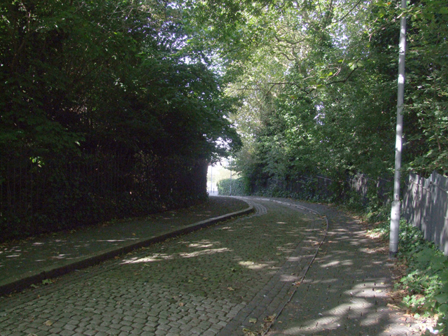
Church Street today, difficult to think this was once teeming with people instead of trees. In the middle of the picture the light area is approximately where the fight took place.
The Barley Mow c.1895 in a watercolour titled “Shove off nipper”. The original is in J. D. Wetherspoons St. Matthew’s Hall pub.
Another illustration from the pubs of old Walsall, this one features the Barley Mow that stood opposite St. Matthew’s Church. Salvation was near at hand but temptation was all around! You will see from the accompanying O.S. map the public houses that were around the St. Matthews area. This area around Church Hill has always been of interest to me ever since childhood, living at the bottom end of Sandwell Street this was our usual route into Walsall town centre. When accompanied by my mother or grandmother in my early years they used to tell me stories about Gorton’s Yard and Temple Street and the hardships endured by the poor families that lived there. I think it was well-known that some of the poorest people in Walsall lived around this area until its demolition in the 1930s.Read More »
During the Middle Ages travel from place to place had not really been necessary as most villages and towns produced the majority of things that they needed themselves. As the population grew in Tudor times and towns began to specialise in particular trades so the need for better roads arose. Although improvements did occur in the area, Walsall’s roads remained in a poor state. After the Turnpike Act of 1747 was passed by parliament turnpike companies built several new roads around the town. For the privilege of continuing on your way travellers either paid up or remained where they were!
Local charges were:-
Coaches and four wheelers 12d (5p)
Chaises and two wheelers 6d (2.5p)
A horse 1d (o.5p)
A drove of oxen 10d (7.5p) per score
A drove of pigs, cows and sheep 5d (2p) per score
Inevitably some people were exempt from paying the toll; these included Members of Parliament travelling to and from London (now there’s a surprise!), serving soldiers, funerals, voters on election day and road menders…..charging the latter would be rubbing salt in the wounds!
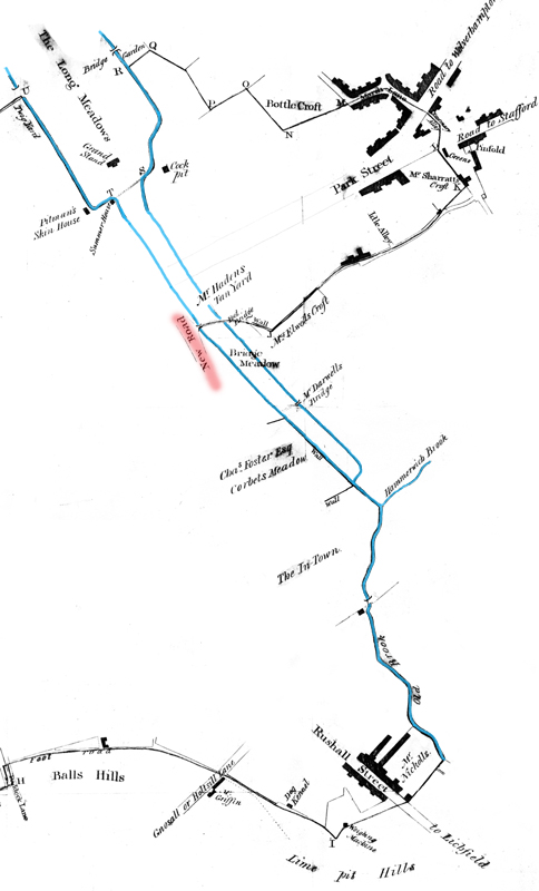
At the bottom of the map shown below can be seen “Dog Kennel” referred to in the Bull’s Head details later in this post. The lack of detail is due to the fact that the map this section is taken from was drawn up to show the boundaries of Walsall Borough only. Anything outside the perimeter, i.e. Hammerwich Brook and Mr Darwall’s bridge, was in the Foreign.
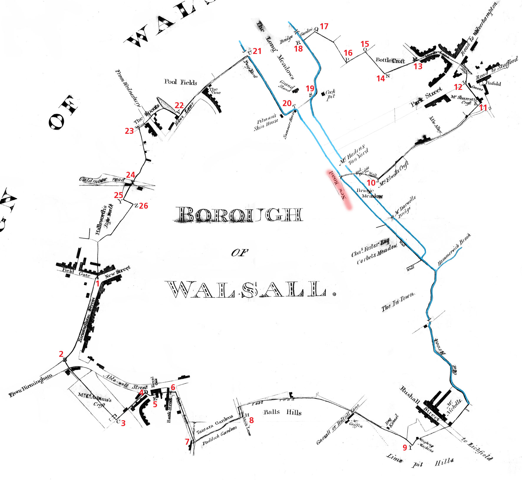
A section of an 1814 map showing New Road (Bridge Street) highlighted in red, the watercourses that ran through the town are shown in blue.
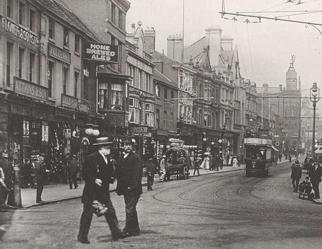
The grocers of Attkins & Son of 5 Park Street is on left side of this photograph taken around 1906. Other business names visible are John Cleland’s a boot and shoe maker, Flower & Sons Ltd., Boots The Chemist and the building to the left of the tram is Ralph Richman’s drapery store. One thing that always intrigued me as a lad was the window that protruded onto Park Street from the New Inn by the ‘Home Brewed Ales’ sign, it was a good 10 or 12 feet in front of the building line! In the distance the Grand Theatre before it lost its tower and in the far distance, Her Majesty’s Theatre. I also like the lad on the far right sitting on some kind of little trolley.
One of the secrets of success in business is location and George Attkins certainly got that correct when he chose Park Street as the base for his grocery business which he started around 1875. George was not a native of Walsall, he was born in Stony Stratford, Buckinghamshire in 1825. Sixteen years later he was listed in the 1841 census as a grocer’s apprentice in his hometown. It would appear he tried his hand at drapery for a short time but realised his destiny lay in the grocery business as the 1871 census lists him having his own grocery business at 39 High Street, Potterspury, just up the road from Stony Stratford.Read More »
A watercolour painting of the original Woolpack Inn c.1885 with the licensee Mrs Emily Eliza Ross standing on the doorstep.
Above is a watercolour of one of Walsall’s oldest inns, The Woolpack, which stood approximately where the entrance to the Old Square is today. The painting shows the original Woolpack which was a late medieval timber framed building and certainly one of the oldest pubs in Walsall, it was demolished in 1892. It is reputed that local Royalists under Colonel John Lane congregated at the inn in September 1651 before continuing to Worcester to join Charles II. During my research for the history of Walsall Races, the Woolpack was mentioned numerous times as it was one of Walsall’s most important venues for cock-fighting. In June 1756 a year after the earliest announcement for Walsall Races in 1755 there appeared in Aris’s Gazette an announcement that read:-Read More »